Collierstown Ride
Ride to the South of Lexington
Washington and Lee University
Campus Life
Student Engagement and Leadership
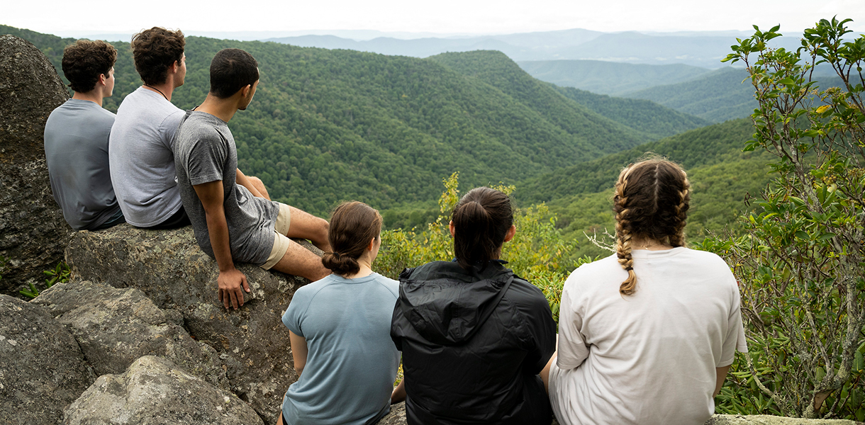
Outdoor Education and Recreation
The Outing Club
Outdoor Activities
Road Biking
Collierstown Ride
- First-Year Experience
- Housing and Residence Life
- Dining
-
Student Engagement and Leadership
- Student Activities and Programs
- Leadership Development
- Religious and Spiritual Life
- Outdoor Education and Recreation
- Office of Health Promotion
- Community Spaces
- Fraternity and Sorority Life
- Health and Wellness
- Safety and Security
- Student Services and Support
- Staff Directory
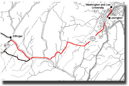
Mile Markers
- 0.0 Begin at the southern edge of Lexington at the junction of US 11 South Business (South Main Street) and Link Road (Highway 251). Turn right, down Highway 251 (Collierstown Road). At the southern edge of Lexington, Link Road quickly becomes Thornhill Road. There are lots of short quick ups and downs and folks tend to drive too fast. Dogs are pretty friendly and well fed.
- 4.5 You’ll encounter a nice stretch of Highway 251 with Buffalo Creek on your left.
- 5.4 Bridge over Buffalo Creek at Murat.
- 5.6 Follow 251 and the Collierstown Road around a sharp right turn. Buffalo Creek will now be on your right on this shady stretch of road.
- 7.2 Junction of 251 and County 612 (Blue Grass Trail).
You Have Two Options
- Short loop and retracing return to Lexington. Turn left on Blue Grass Trail (612), follow it for .9 mile, then turn a very sharp left on County 677 (Kygers Hill Road), follow it up over the Jerry Hines Bridge. After another .9 miles, you’ll crest the hill with gorgeous views of House Mountain. Continue another mile down hill and reintersect with the Collierstown Road. 10.0 Intersection of Kygers Hill Road (677) and Collierstown Road. Continue Straight on 251 north and additional 5.6 miles back to Lexington (total ride length 15.6 miles).
- The backway return in the shadows of House Mountain – Continue on Collierstown Road (251) another 3 miles.
Mile Markers
- 9.5 You’ll enter the burg of Collierstown.
- 9.9 Junction with County Road 672 (Turnpike Road). Take a sharp right. For the next 5 miles or so this is a pretty quiet, shady, windy, almost flat road with nice views of House Mountain off to your left.
- 16.4 Junction with Enfield Road. Turn right onto Enfield Road which climbs up over the crest of Brushy Hills overlooking the outskirts of Lexington.
- 18.6 Lexington City limits and the Lexington Water Tower.
- 19.3 Junction with McLaughlin Street. Take a left, and you’ll be at the Lenfest Center and in sight of the DARC after 100 yards.
- First-Year Experience
- Housing and Residence Life
- Dining
-
Student Engagement and Leadership
- Student Activities and Programs
- Leadership Development
- Religious and Spiritual Life
- Outdoor Education and Recreation
- Office of Health Promotion
- Community Spaces
- Fraternity and Sorority Life
- Health and Wellness
- Safety and Security
- Student Services and Support
- Student Affairs Staff
Katelyn Nicely
Outdoor Education and Recreation Operations Manager
- P: 540-458-8039
- E: knicely@wlu.edu